







LIBRO INGLESE





Road Atlas Ireland: A4 Paperback Touring Edition

8,74 €
+90
punti 
Venditore: Feltrinelli
Articolo acquistabile con Carta del Docente

Articolo acquistabile con Carta Cultura Giovani e Carta del Merito

Articolo acquistabile con Carta della Cultura

Dati e Statistiche
 Salvato in 0 liste dei desideri
Salvato in 0 liste dei desideri
Road Atlas Ireland: A4 Paperback Touring Edition
Disponibile in 5 gg lavorativi
8,74 €
8,74 €
Disponibile in 5 gg lavorativi
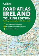




Explore Ireland with this accurate and fully updated road atlas. This road atlas is at A4 size, covering the whole of Ireland and features clear and detailed Collins colour mapping at a scale of 5.2 miles to 1 inch. Perfect for both residents and visitors touring Ireland. This revised edition includes: Places of tourist interest Contact information for Tourist Information Centres with grid references to the mapping Fully indexed street maps of 11 cities and towns – Dublin, Belfast, Cork, Limerick, Waterford, Londonderry (Derry), Galway, Bangor, Dun Laoghaire, Drogheda and Killarney Blue Flag & Green Coast beaches Ferry and airport information; Distance chart; Distances marked on the roads in miles and kilometres Route planning map of the whole of Ireland at 15.8 miles to 1 inch Administrative map of Irish counties and districts.
-
Autore:
-
Editore:
-
Collana:Collins Road Atlas
-
Anno:2026
-
Rilegatura:Paperback / softback
-
Pagine:64 p.
Testo in English
Dimensioni:
297 x 210 mm
Peso:
260 gr.
EAN:
9780008787462

Informazioni e Contatti sulla Sicurezza dei Prodotti
Le schede prodotto sono aggiornate in conformità al Regolamento UE 988/2023. Laddove ci fossero taluni dati non disponibili per ragioni indipendenti da Feltrinelli, vi informiamo che stiamo compiendo ogni ragionevole sforzo per inserirli. Vi invitiamo a controllare periodicamente il sito www.lafeltrinelli.biz per eventuali novità e aggiornamenti.
Per le vendite di prodotti da terze parti, ciascun venditore si assume la piena e diretta responsabilità per la commercializzazione del prodotto e per la sua conformità al Regolamento UE 988/2023, nonché alle normative nazionali ed europee vigenti.
Per informazioni sulla sicurezza dei prodotti, contattare productsafety@feltrinelli.it
